Wednesday, May 31, 2006

Foliation & Lineation

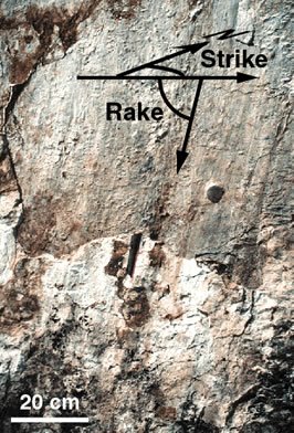
This week I'll be heading out to do more research with Dr. Dinklage, this time out in the Pequop Mountains in Nevada. We will be working with more metamorphic rocks. One characteristic that some metamorphic rock may contain is foliation and lineation. They are defined as follows: Foliation - The arrangement of a set of minerals in parallel, sheet-like layers that lie perpendicular to the flattened plane of a rock. Occurs in metamorphic rocks on which directed pressure has been exerted. Lineation - Minerals that are linear or have been positioned or deformed in the same direction due to stress and strain. These characteristics occur because tremendous amounts of force deform the rocks during an orogeny, or mountain building. Heat and pressure are what determine how a rock will deform. It could become low grade (little metamorphism) to high grade (great metamorphism).

Friday, May 26, 2006

An Abyss

It's funny that we know more about space than we do about what's under the ocean. Distance isn't a barrier this time, it is the water. Pressure inscreases as you go deeper in water and the refraction of like eventually scatters all the light before you get too deep. On average the depth of the ocean is 4000 meters. But it can get much deeper in some areas. As I have explained in a previous blog about subduction zones, a trench is formed as one plate slips under another plate. These trenches can get very deep. The deepest trench is the Mariana Trench by the Mariana Islands. The trench is over 11,000 meters deep. A few brave fellow tried to see how deep they could go. The famous HMS Challenger II made the trip out there and the submersible called Trieste made the trip down. The men were in for a scare when the 3 inch plexiglass window cracked on the way down. The though if it broke they would be goners anyway so the proceeded to find the deepest point. They came very close, close enough to consider it to be the deepest and the men made it back alive. Anything deeper than 4000 meters is considered abyssalpelagic. If it is a plain, it is an abyssal plain.

"...when you look long into an abyss, the abyss looks back into you."
-Friedrich Nietzsche

Wednesday, May 24, 2006

Crystal Clear


An important tool for geologists out in the field is a hand lens. It is like a little magnifying glass that help geologists look at what crystals or minerals are in the rock that are not as visible with the naked eye. Most have power or magnification 10 times greater than normal vision. You can get some that are 15 or 20 times, and some even greater, but you start loosing depth very quickly and you'll need to look at a flat surface. Gemologists will also use a hand lens before, during, and after cuting a gem to inspect it.

Monday, May 22, 2006

GSA Regional Meeting

I just recently returned from the Geological Society of America (GSA) Regional Meeting that was held in Gunnison, Colorado this year. I went with my professor and some collegues to present some of the research we did last summer. It was structure and tectonics of the Santaquin Metamorphic Complex. I was a little intimidated around all these bright, intellegent geologists. Luckily there were some other undergrad students there that I could relate with. There was a young girl that was a sophmore in high school that had done some research with a professor. She presented her research at a science fair and won a $50,000 scholarship for it! She's set for life, but all well deserved. A lot of the info was above my head, but I did learn a few things. I learned what a knickpoint is, which is a change in gradient of a stream/river bed to a steeper angle. This increases flow velocity and weathering and erosion increase. This occured in the Black Canyon of the Gunnison which has carved a steep, narrow, deep canyon through the metamorphic amphibolite gneiss. Pegmatite dikes beautifully paint the walls of the canyon.

Monday, May 15, 2006

Slickensides

Geology has some funny names to it. One way to recognize a fault is sometimes an outcrop will be exposed on the fault scarp. (The fault scarp is the visual slip on the fault.) When there is a break across a rock unit, the rocks will slide along each other. With the intense forces, this will often make the slip surfaces on the rock very smooth with charateristic grooves. These smooth surfaces are what we call slickensides. Sounds almost like a water park. The grooves are called slickenlines. As part of our research in Santaquin, Utah, we came across many outcrops that contained these slickensides. We measured their orientation and plotted them on a graph that plots 3D planes on 2D paper, called a stereonet. The interesting thing about these little faults in the Santaquin Metamorphic complex, is that they were all dipping (or slanting downward) to the east, when the Wasatch fault dips to the west. Apparently these little faults did not occur at the same time as the Wasatch Fault era.

Friday, May 12, 2006

Divergent Boundaries


Another type of plate boundary is a divergent plate boundary. Divergence occurs when extention takes place. You can remeber that divergence sound like divide. At theses boundaries a ridge will occur. It may look like there is mountain build but that happens with compression. As the plates split, the crack is filled in with underlying magma, which solidifies when it comes in contact with the cold ocean water, making new oceanic crust. This process continues and the older crust proceeds away from the ridge. As it gets older and cools down, it becomes more dense and sinks even lower into the Earth. These boundaries can also occur on land as well as under the ocean. Part of the mid-Atlantic ridge goes through part of Iceland. Another rift valley that is occuring is in the eastern part of Africa. As that rift valley splits it will eventually sink below sea level and be split off from the rest of Africa.
Another Selection For Your Gee Wiz Collection:
If the Earth did not experience plate tectonic, the land would never replenish itself. The land would evenually be all weathered away and eroded to to the oceans and there would be no land to live on.

Thursday, May 11, 2006

A Turbid Environment

I would hate to be in an avalanch or a landslide. But you know, on land is not the only place they can occur. It can also happen in the oceans. An underwater landslide is called a turbidity current. What happens is that sediment is carried by rivers to the oceans. When the rivers hit the oceans, the water velocity slows down and deposits the sediment. It eventually builds up over time. Sometimes the weight of overlying sediment becomes so great that the underlying sediment will fail and a turbidity current, or underwater landslide, will occur. Turbidity currents will form submarine canyons. Be careful if you're big on scuba diving. Chances are few you'll get caught in one but better safe than sorry.

Wednesday, May 10, 2006

Learning Is Fun

You know, science is not all that boring if you think about it. It can be fun if you get the right teacher, and I hope to be that way with my students. I am reminded of the sting ray on the movie Finding Nemo. He made learning fun for the kids. I actually used a clip of it in one of my lessons to demonstrate a learning memory model. The subject was the zones of the ocean. The ocean is split up into zones to help classify it. In Mr. Ray's song he says, "Let's name the zones, the zones, the zones. Let's name the zones of the open sea. There's epipelagic, mesopelagic, bathypelagic, abyssopelagic, all the rest are too deep for you and me to see!" I had the class learn the song and sing it with the movie. Most of them had no idea what Mr. Ray was talking about until it was explained in a fun way. I hope to be like Bill Nye when I start teaching.

Monday, May 08, 2006

Abide With Me, Tis Evenin' Tide


Some times the ocean itself seems alive. Why are there tides and what causes them. It all starts out with gravity. Gravity is not a very strong force, compared to electomagnetic forces, or the strong forces that hold quarks together, but it is a long force. It's amazing how far a field of gravity will reach. Such is the case with the tides. Gravitational forces, pricipally from the moon, and from the sun will pull the ocean closer too it which will pull the water in or out to sea according to the possition of the sun and moon. There are several classifications of tides. A Spring tide is when the tide is higher than average. A Neap tide is lower than average. Tides can also be classified as diurnal or semidiurnal, meaning they occur once or twice a day.

Friday, May 05, 2006

The True Universal Giants

Have I told you how much I love astronomy. I think that the expanse of space is spectacular. We are so small and tiny compared to what is all out there, and to think how much smaller molecules or even atoms, (or even the quarks that make up the atoms for that matter, no pun intended) they are compared to us. How big is the Earth? Well, if you were going the speed of light, which is 300,000,000 meters in one second, you could travel around the earth a little over seven times in one second. Light traveling from the sun to the Earth takes about eight minutes. That's quite the distance. Jupiter's orbit is about 5 times the diameter of Earth's orbit around the sun. Now, that you have a sense of scale, check out the size of that star in the picture (ignore the "click to enlarge"). That is a picture of Betelguese, a red giant star in the constalation Orion. The diameter of the star nearly exceeds the diameter of Jupiter's orbit around the sun. WOW and I mean WOW! It amazes me how big things are out there, and that is only one star out of billions in our galaxy. Feeling small and insignifigant yet? Me too.

Santaquin Analysis

If I may share a little bit of the research I did with Dr. Dinklage in the Santaquin Metamorfic Complex (SMC) I would be much abliged. I want to refresh some of the work we did before I present it the week after next. We submitted our research the the Geological Society of America (GSA) to be published and presented at a branch conference in Gunnison, Colorado. Loads of geologist will be there and I'm a little nervous. What if they start asking me all sorts of complicated stuff I don't know. I'm only an undergrad student. I'm sure it will be fun. To analyse some of the stresses in the rock, what a geologist will do is slice a piece of the rock really thin, to about 30 micrometer (1,000,000 micrometer = 1 meter) and look at it through a petrographic microscope. It is very similar to a microbiologist looking through a microscope at cells, bacteria, etc., except geologist look at minerals. In some of our samples we could see microscopic fractures and minerals that have changed their composition due to hydrothermal alteration. The picture above is an example of a thin section. The colorful circle occurs when a polarized filter is put into place. It only allows light at certain wave lenghts to past throught that are reflected of the crystal, which can help identify what kind of mineral it is.

Thursday, May 04, 2006

Holy Hurricane!


Another terror that comes from the oceans are hurricanes, cyclones, and typhoons. Lets not forget the damage done to our south eastern United States after hurricane season. I will not throw in any opions about New Orleans due to the possible sensitivity of any readers, however, as a geologist, my professional opinion would have been to NOT build the city on unconsolidated sediment. Or in other words: To have not built the city on a delta of sand which is sinking several inches a year. Building below sealevel on the coast is not wise for any geological surveyor. Ever notice that we mostly have hurricanes up the east coast and not the west coast? Well, it is possible but it is more common for them to form in warm tropical regions and follow the ocean currents northward near the coast.
Another Selection For Your Gee Wiz Collection
What are the differences between a hurricane, cyclone and typhoon? Hurricanes form in the Atlantic Ocean, cyclones form in the Indian Ocean, and typhoons form in the Pacific ocean.

Wednesday, May 03, 2006

Tsunami: No Joking Matter


The think I love the most about geological hazards is how much power mother earth has. It could totally wipe us out. I previously spoke about earthquakes and the mass destruction they can do. The most powerful type of earthquake is at a subduction zone. That is when one tectonic plate collides with another and one plate is subducted under the other. The huge amount of friction gives greater strenght to deformation and a very nasty break when it slips. The highest recorded earthquake at a subduction zone (and anywhere on the earth) was classified as a 9.2 on the moment magnitude scale. That scale is a logorithmic function where as an earthquake classified as a 2 would be 10 times more powerful than one classified as a 1. So a 9.2 is over a billion times more powerful than a 1. Another danger of a subduction zone slipping is it will create tsunamis. When the ocean suddenly goes far out to sea, head for high hills because a tsunami is about to hit! If that makes you nervous, maybe you should move inland.
Another Selection For Your Gee Wiz Collection:
The tsunami that recently occured in Sumatra released so much energy when it slipped, it would be similar to over 10,000 bombs that landed on Hiroshima.

Tuesday, May 02, 2006

Earth Science Country


Hi, my name is Darwin and I'm a Earth Science Major. I'm working on an emphasis in secondary education. I'm currently attending UVSC right now and will graduate in the Spring of 2007. I am also a student of all sciences. I especially love astronomy. I've done some research with some of my professors the past couple years. I first worked on a report for the state department on Utah Lake. My subject was mineral resources and hydrocarbon potention. I also have done some research in the Santaquin metamorphic complex. We studied fractures and mineralization in fractures to understand stresses in the area, time of deformation, and see if there is any relation to the Wasatch Fault. This blog will contain many topics related to Earth science and similar topics.
Gee Wiz Collection:
The Wasatch Fault extends from Brigham City, UT to Levan, UT and can create and earthquake as large as 7.5 on the moment magnitude scale. As scary as that may sound, earthquakes are usually dormante for very long periods of time, and the area is a beautiful place to live. Utah too much of a desert for you? Then I would check out a home along the coast.